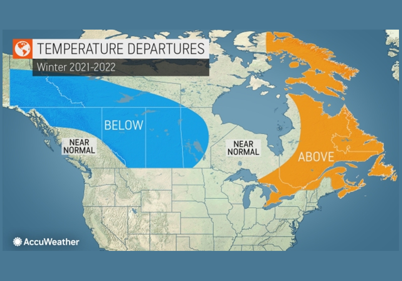
The report spells out what different areas of the country can expect from a weather perspective over the winter months.
La Niña is present far out in the Pacific Ocean once again this year, Anderson says it will play a key role in the overall weather pattern this coming winter.
This year, Anderson said frosty conditions could make a biting return, although he says some areas of the country could be spared. La Niña effect on Canada, particularly in the western half of the country, will probably send temperatures falling even lower than they do during the average winter.
“The upcoming winter is expected to be fairly stormy from southern British Columbia through the Canadian Rockies with many opportunities for significant rainfall and strong winds along the coast,” Anderson said. “Abundant snowfall is expected throughout much of ski country from the Coastal Range of British Columbia through the Rockies of western Alberta.”
Anderson says central Canada will welcome a polar vortex a few times during the winter months – bringing bitter and brutal weather for a few weeks.
“I believe we may see at least three extreme blasts of bitterly cold air dropping down into the southern Prairies this winter,” Anderson said, noting that temperatures could plunge lower than 20 degrees below zero Fahrenheit (30 below zero C) on those occasions. “This winter will likely end up colder than the winter of 2018-2019 and the coldest winter since 2013-2014 in the region.”
Anderson says southern Alberta and Saskatchewan should expect temperatures that are 3 degrees Fahrenheit lower than average.
Ontario and Quebec will not be spared, those two provinces should expect increased snowfall thanks to the polar jet stream; but Anderson predicts above-average temperatures are to be expected in eastern half of the country. Atlantic Canada should expect a milder winter with average snowfall.
“The greatest threat for powerful coastal storms in Atlantic Canada will come in February,” he said. “The clash of advancing cold air from the west with the abnormally warm waters of the northwest Atlantic may lead to some rapidly developing storms with a lot of wind and heavy precipitation from the Maritimes to Newfoundland.”

